
Professional Service
Mapping & Measurement
Land measurement and geospatial data analysis services
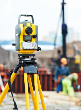
Mapping & measurement are professions closely related to measurement, mapping, and geospatial data analysis. Both play a crucial role in various sectors, such as construction, mining, transportation, and natural resource management. Below is a detailed of the work of surveyors and mapping professionals. Aspect: Measurement, Mapping. Work Focus: Direct measurement of land surfaces and physical elements, Creating and analyzing maps and survey data. End Result: Measurement data in the form of coordinates or dimensions, Maps or geospatial data visualizations. Work Methods: Using measurement tools in the field, Using software and geospatial data. Key Technology: Total Station, Theodolite, GPS Geodetic, Auto Level, ArcGIS, Civil3D, etc. Orientation: Precision in measurement and physical documentation, Data visualization and spatial analysis.
Key Benefits
ISO-certified quality assurance
Experienced certified professionals
Advanced equipment & technology
Comprehensive documentation
Timely project delivery
Competitive pricing
Service Information
Category
Industrial Services
Certification
ISO Accredited
Response Time
Within 24 Hours
Availability
Year-round Service
Need Assistance?
Our team is here to help you find the right solution for your needs.
Related Services
Explore other services that might interest you

Request a Quote for This Service
Fill out the form below and our team will get back to you within 24 hours
Get in Touch
We're here to answer your questions and provide the best solutions for your industrial needs.
hello@acmindo.com
Phone
+62 812 3456 7890
Office
Batam | Jakarta | Cilegon
Working Hours
Mon - Fri: 8AM - 5PM